2006, the Antarctic ozone hole.
In this image, from September 2006, the Antarctic ozone hole was equal to the record single-day largest area of 11.4 million square miles (29.5 million square kilometres), reached on Sept. 9, 2000. Satellite instruments monitor the ozone layer, and we use their data to create the images that depict the amount of ozone. The blue and purple colours are where there is the least ozone, and the greens, yellows, and reds are where there is more ozone. (Photo by: Universal History Archive/ Universal Images Group via Getty Images)

EINE LIZENZ KAUFEN
Wie darf ich dieses Bild verwenden?
335,00 €
EUR
Getty Images2006, the Antarctic ozone hole., Nachrichtenfoto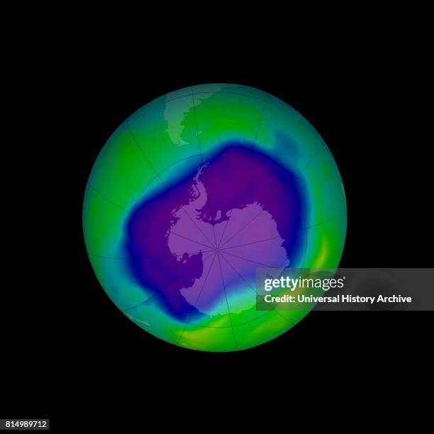 2006, the Antarctic ozone hole. Erstklassige Nachrichtenbilder in hoher Auflösung bei Getty ImagesProduct #:814989712
2006, the Antarctic ozone hole. Erstklassige Nachrichtenbilder in hoher Auflösung bei Getty ImagesProduct #:814989712475€150€
Getty Images
In stockBitte beachten Sie: Bilder, die historische Ereignisse darstellen, können Motive oder Beschreibungen beinhalten, die nicht der gegenwärtigen Auffassung entsprechen. Sie werden in einem historischen Kontext bereitgestellt. Weitere Informationen.
DETAILS
Einschränkungen:
Bei kommerzieller Verwendung sowie für verkaufsfördernde Zwecke kontaktieren Sie bitte Ihr lokales Büro.
Bildnachweis:
Redaktionell #:
814989712
Kollektion:
Universal Images Group
Erstellt am:
31. August 2006
Hochgeladen am:
Lizenztyp:
Releaseangaben:
Kein Release verfügbar. Weitere Informationen
Quelle:
Universal Images Group Editorial
Objektname:
917_03_WHA_098_0568
Max. Dateigröße:
4579 x 4579 px (38,77 x 38,77 cm) - 300 dpi - 1 MB